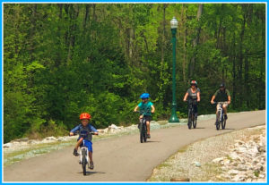
Hiking and Biking Trails
Quite simply Benton County offers some of the best hiking and biking trails in the state–and in the country. That’s according to MoBikeFed, the League of American Bicyclists and the Alliance for Biking and Walking. In fact, each have visited and seen first-hand our trails system and bicycle and pedestrian facilities.
Hiking and Biking options in Benton County
We have a mountain bike and hiking park, and a park and trail system in Warsaw’s downtown harbor area. Additionally, we have levee and riverfront trails and connecting both sides of the river is the Joe Dice Swinging Bridge.
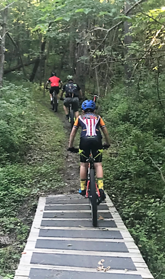
Truman Lake Mountain Bike & Hiking Area

Overall, these trails are a great place to get away! Undoubtedly, the trails in Benton County let you escape for the day, or for the weekend. They offer 25+ miles of backcountry fun, breathtaking views, and access to fantastic swimming holes. Basically, these trails are a beaten path single track that offers an off-road riding/hiking experience for the beginner and the advanced. Likewise, several colored trails can help guide you around or mix up different sections for a whole new adventure. However, no motorized vehicles or horses are allowed in the park.
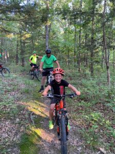
The Truman Lake Bike Club teamed up with the U.S. Army Corps of Engineers and the City of Warsaw to bring this exciting mountain bike trail to the area. Truman Lake Mountain Bike Park has been built on Corps of Engineer land bordering beautiful Truman Lake. It is located at 28565 Benton House Avenue, only two miles west of 65 Highway and North Dam Access Road in Warsaw, Missouri.
Warsaw Chamber of Commerce presents the Missouri State Championship bike races at the Truman Lake Mountain Bike Park. View the Park brochure or call the Warsaw Area Chamber of Commerce at 660-438-5922 for more information.
Additional Information
- Warsaw Adventures Bike Rental and Outfitter
- International Mountain Bike Association (IMBA)
- Missouri Bicycle Federation
- Off-Road Fixation
- SingleTrack
- Trails
- Truman Lake Adventure Club
- United Federation of Dirt
- United States Adventure Racing Association (USARA)
- USA Cycling
- Wildernet
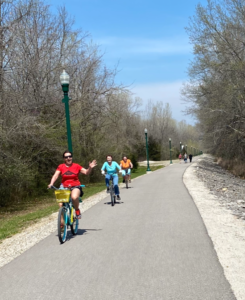
The Riverfront Trails
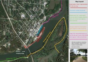
Enjoy the great outdoors in beautiful Warsaw, MO!! You can hike or bike to Bledsoe Ferry, Truman Dam, Shawnee Bend and beyond. Furthermore, enjoy the gorgeous views of water and wildlife on over ten miles of family-friendly flat trails.
On the National Historic Register, The Joe Dice Swinging Bridge spans the Osage Arm of Lake of the Ozarks. Markedly, this historic bridge is a vital part of Warsaw’s Riverfront trails system. Additionally, you can ride across Truman Dam and connect with bicycle-friendly road routes that take you on a tour of Warsaw.

The Warsaw Riverfront and trail system has continued to grow by leaps and bounds the last several years! The unique trail system that runs along the Osage Arm of Lake of the Ozarks/Lake of the Ozarks. Not to mention, it links 3 major parks, creating a linear park along this scenic waterfront area with beautiful views of the Ozark Hills, bluffs, lakes, and greenways!!
12 miles of waterfront trails that are great for walking, running, and bicycling! Whereas, along these trails, you will find many species of waterfowl, bald eagles, deer, turkey, and more. In addition, there are areas to picnic, bird watch, or work on your nature photography! Surprisingly, throughout the unique trail system there are a 9 hole disc golf course, horseshoe pits, numerous picnic and play areas, an amphitheater, festival areas, a gazebo, boat launch areas, boat slips, Sports Complex, and Truman Lake Dam. In addition, there are many peaceful areas to simply relax and enjoy the scenery.
Additionally, the historic Joe Dice Suspension Bridge is an added historical and cultural feature. Previously, the swinging bridge was a transportation route for horses and automobiles (single lane) at one point but today is used for bicyclists and pedestrians and serves as a major link for the trail system. Notably, it is the only link from one side of the waterfront to the other. The bridge is on the National Historic Registry.
This map will show you the distances and locations of each trail. If you have not visited lately, you are missing out on a great getaway!! Come visit and feel free to have fun!!!!
Shawnee Bend Bluff Trail
Take the West Dam Access Road to Shawnee Bend Park. At the top of the boat ramp parking lot is the Shawnee Bend Trailhead. Enter around the yellow gate.
The trail is a 2.3 mile loop trail that is primarily used for hiking, walking, and nature trips and is accessible year-round.
The Butterfield Experience
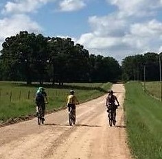
Bike packing, day-tripping, and overnight stays.
Want to go exploring “off the beaten path”? The MO Bike Federation has created a website to find these historical routes and mapping (including GPS maps) linking Benton County to other major trail systems.
history of the butterfield
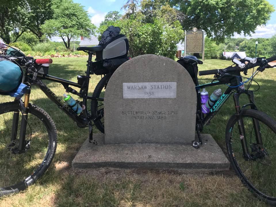
The Butterfield Overland Stage Trail operated from 1858 through 1861. During this time, it carried mail and passengers from Tipton, Missouri, to San Francisco, California. The trip was 22 days long and ran each direction twice per week. Conversely, during the Civil War, the trail was used as a military trail by both Union and Confederate Armies.
Approximately 160 years later, the 250-mile route through Missouri has become the Butterfield Stage Experience. Whereas, it is known for its unique history and beautiful scenery, the Butterfield Stage Experience allows riders of all kinds to enjoy the back-road gravel riding at it’s finest.
![]()
How to experience the butterfield
You will fall in love with this section of the Butterfield Overland Stage route. With the addition of the Butterfield connection to the Rock Island and the Katy Trail in Windsor, Missouri, these fabulous backcountry gravel roads entice us to explore Benton county and the hidden gems of our area. Whereas each community has its own unique history, all are connected to the Butterfield Overland Stage Route. When you connect to Warsaw, even more outdoor adventure awaits.
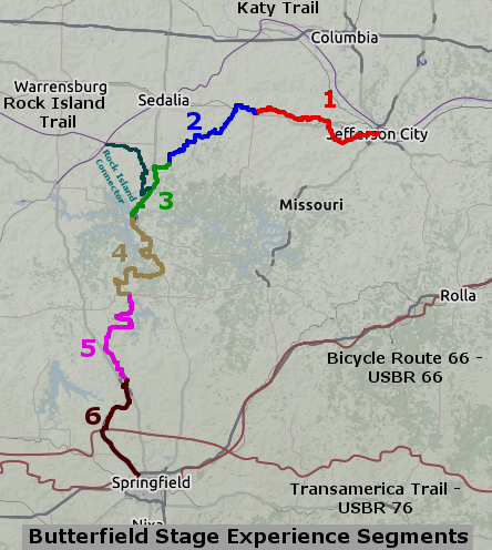
The Butterfield Stage Experience is a new mostly gravel bicycle touring route consisting of county gravel roads and multi-use trails using/paralleling the historic Butterfield Stage Route in Missouri.
Currently, over 250 miles in length, the route is a low-traffic trail-like experience that leads you straight to the heart of rural Missouri and visits many of the historic Butterfield Stage sites and monuments across the state. Additionally, this route is accessible to most who enjoy natural-surface routes like the Katy Trail and Rock Island Trail. It’s perfect when you are ready to take the next step towards adventure.
learn more about the butterfield
The route is mostly on well-maintained county gravel roads and multi-use trails. Additionally, you will find a few mountain bike trail routes and occasional paved sections as needed for connectivity.
- Great for day trips, weekend getaways, or a few days of bike camping or backpacking.
- Connect to the Katy, Rock Island, and Frisco Highline Trails.
- Go explore Missouri in a whole new way and be sure and check out the Warsaw, Lincoln and Cole Camp connections.
Click here for more information on the Butterfield Stage Experience on MObikefed.org